Earth Solar System
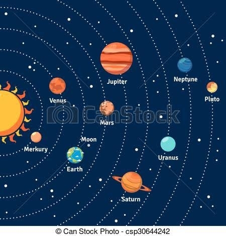
Earth solar system consists of :
• The Sun • The Planets
• Dwarf Planets & countless fragments of left – overs called asteroids, meteors, comets & satellites of the planets (Called small solar system Bodies).
Solar System Some Facts
• Biggest Planet : Jupiter
• Smallest Planet : Mercury
• Nearest Planet to Sun : Mercury
• Farthest Planet from Sun : Neptune
• Nearest Planet to Earth : Venus
• Brightest Planet : Venus
• Brightest star after Sun : Sirius
• Planet with maximum satellites: Jupiter
• Coldest Planet : Neptune
• Hottest Planet : Venus
• Heaviest Planet : Jupiter
• Red Planet : Mars
• Biggest Satellite : Ganymede
• Smallest Satellite : Deimos
• Blue Planet: Earth
• Morning/Evening Star : Venus
• Earth's Twin : Venus
• Green Planet : Neptune
• Planet with a big red spot : Jupiter
• Lord of the Heavens : Jupiter
• Greatest Diurnal Temperature: Mercury
Earth Latitude & Longitude
Earth Latitude
• Imaginary lines drawn parallel to the equator. Measured as an angle whose apex is at the centre of the earth.
• The equator represents 0° latitude, while the North Pole is 90° N & the South Pole 90° S
• 23½° N represents Tropic of Cancer while 23½° S represents Tropic of Capricorn.
• 66½° N represents Arctic Circle while 66½° S represents Antarctic Circle.
• There are total 181 latitudes including the equator. Each parallel of latitude is a circle, but they are not equal.
• The circle becomes smaller toward`s the poles. Equator is the ‘Greatest Circle’ that can be drawn on the earth’s surface.
• The distance between any two parallels of latitude is always equal.
• 1 degree lat. = 111km.
Earth Longitude
• It is the angular distance measured from die centre of the earth. On the globe the lines of longitude are drawn as a series of semicircles that extend from the North Pole to the South Pole through the equator. They are also called meridians.
• The distance between any two meridians is not equal.
• At the equator, 1 degree = 111 km. At 30°N or S, it is 96.5 km. It goes on decreasing this way until it is zero at the poles.
• There are 360 meridians of longitude. The prime meridian is a longitude of 00, passing through the Royal Observatory at Greenwich near London.
• This meridian is taken by geographers to divide the earth into the eastern & the western hemispheres.
• Each meridian of longitude is a semi-circle. 180° meridian (International Date Line) lies exactly opposite to 0° meridian. Such points are called Antipodal Points.
• The earth is divided into 24 longitudinal zones, each being 15° or 1 hour apart in time (4 minutes / degree).
Longitude & Time
• Places that are on the same meridian have the same local (sun) time. Since the earth makes one complete revolution of 360° in 24 hours, it passes through 15° in one hour or 1° in 4 minutes.
• The earth rotates from west to east, hence places east of Greenwich see the sun earlier & gain time whereas places west of Greenwich see the sun later & lose time.
• India, whose longitudinal extent is approx. 30°, has adopted only one time zone, selecting the 82.5°E for the standard time which is 5 hours & 30 minutes ahead of GMT (Greenwich Mean Time).
International Date Line
• It is the 180° meridian running over the Pacific Ocean, deviating at Aleutian Islands, Fiji, Samoa & Gilbert Islands. It is a zig-zag line
• Travelers crossing the Date Line from west to east (i.e., from Japan to USA) repeat a day & travelers crossing it from east to west (i.e., from USA to Japan) lose a day.
Important Parallels of Latitude
1. The Tropic of Cancer: It is in the northern hemisphere at an angular distance of 23 1/2° (23°30’N) from the equator.
2. The Tropic of Capricorn: It is in the southern hemisphere at an angular distance of 23 1/2° (23°30’S) from the equator.
3. The Arctic Circle: It lies at a distance of 66 1/2° (66°30’N) north of the equator.
4. The Antarctic Circle: It lies at a distance of 66 1/2° (66°30’S) south of the equator. There are two solstices each year, called the Summer Solstice & the Winter Solstice.
Summer Solstice: The day of 21st June when the sun is vertically overhead at the Tropic of Cancer (23°30’N). Longest day in Northern Hemisphere.
Winter Solstice: The day of 22nd December when the sun is vertically overhead at the Tropic of Capricorn (23°30’S). Shortest Day in Northern Hemisphere.

Meridians of Longitude
The semi-circles running from pole to pole or from north to south are known as meridians of longitude & distance between them is measured in degrees of longitude. Greenwich Meridian or Prime Meridian with a value of 0° longitude serves as a common base for numbering meridians of longitude lying on either side of it — east as well as west. There are 360 meridians including Prime Meridian. Each degree of a longitude is divided into sixty equal parts, each part is called a minute. Each minute is again divided into sixty equal parts, each part being called a second.
Local Time : Local time of any place is 12 noon when the sun is exactly overhead. It will vary from the Greenwich time at the rate of four minutes for each degree of longitude.
Greenwich Mean Time : The time at 0° longitude is called Greenwich Mean Time. It is based on local time of the meridian passing through Greenwich near London.
Indian Standard Time : It is fixed on the mean of 82 1/2°E Meridian, a place near Allahabad. It is 5 1/2hours ahead of Greenwich Mean Time.
Facts about earth
• The Earth also called Blue Planet. It is the densest of all planets.
• Earth Circumference: 40,232 Kilometers.
• Earth Area: 510 million Square Kilometers
• Average distance from sun: 149 million Kilometers.
• Earth Perihelion: Nearest position of earth to sun. The earth reaches its perihelion on January 3 every year at a distance of about 147 million-Kilometers.
• Aphelion: Farthest position of earth from sun. The earth reaches its aphelion on July 4, when the earth is at a distance of 152 million Kilometers.
• The shape of the earth is oblate spheroid or oblate ellipsoid (i.e. almost spherical, flattened a little at the poles with a slight bulge at the centre).
Types of Earth Movements:
1. Rotation or daily movement.
2. Revolution or annual movement.
Earth Rotation
• Spins on its imaginary axis from west to east in 23 hrs, 56 min & 40.91 sec.
• Rotational velocity at equator is 1667 Kilometers/h & it decreases towards the poles, where it is zero.
Earth’s rotation results in
i. Causation of days & nights;
ii. A difference of one hour between two meridians which are 15° apart;
iii. Change in the direction of wind & ocean currents; Rise & fall of tides everyday.
iv. The longest day in North Hemisphere is June 21, while shortest day is on 22 Dec (Vice-versa in S.Hemisphere).
• Days & nights are almost equal at the equator.
Earth Revolution
• It is earth’s motion in elliptical orbit around the sun. Earth’s average orbital velocity is 29.79 Kilometers/s.
• Takes 365 days, 5 hrs, 48 min & 45.51 sec. It results in one extra day every fourth year.
• Revolution of the earth results in
i. Change of seasons
ii. Variation in the lengths of days & nights at different times of the year
iii. Shifting of wind belts
iv. Determination of latitudes.
Earth Eclipses
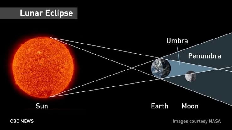
Earth Lunar Eclipse
Ø When earth comes between sun & moon.
Ø Occurs only on a full moon day. However, it does not occur on every full moon day because the moon is so small & the plane of its orbit is tilted about 5° with respect to the plane of the earth’s orbit. It is for this reason that eclipses do not occur every month.
Ø This light is red because the atmosphere scatters the other colors present in sunlight in greater amounts than it does red.
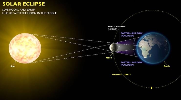
Earth Solar Eclipse
A solar eclipse is a type of eclipse that occurs when the Moon passes between the Sun & Earth, & the Moon fully or partially blocks ("occults") the Sun. This can happen only at new moon
INTERIOR STRUCTURE OF THE EARTH
The layering of Earth is categorized as Lithosphere, Asthenosphere, Upper mantle, Lower mantle, Outer core, & the Inner core.
The earth's interior has three different layers; they are
(i) the crust (ii) mantle & (iii) the core.
a) Earth's Crust:
All of the Earth's landforms (mountains, plains, & plateaus) are contained within it, along with the oceans, seas, lakes & rivers.
Ø There are two different types of crust: thin oceanic crust that underlies the ocean basins & thicker continental crust that underlies the continents.
Ø The boundary between the crust & the mantle is Mohorovicic Discontinuity.
b) Earth's Mantle: It is the thick, dense rocky matter that surrounds the core with a radius of about 2885 km.
Ø The mantle covers the majority of the Earth's volume. This is basically composed of silicate rock rich in iron & magnesium.
Ø This layer is separated from the core by Gutenberg-Wiechert Discontinuity.
Ø The outer & the inner mantle are separated by another discontinuity named Repetti discontinuity.
c) Earth's Core: Earth's Core is thought to be composed mainly of an iron & nickel alloy.
Ø The core is earth's source of internal heat because it contains radioactive materials which release heat as they break down into more stable substances.
Ø The core is divided into two different zones.
Ø The outer core is a liquid because the temperatures there are adequate to melt the iron-nickel alloy.
Ø However, the inner core is a solid even though its temperature is higher than the outer core. Here, tremendous pressure, produced by the weight of the overlying rocks is strong enough to crowd the atoms tightly together & prevents changing it to the liquid state.
ATMOSPHERE
Atmosphere is a thick gaseous envelope that surrounds the earth & extends thousands of kilometers above the earth's surface. Much of the life on the earth exists because of the atmosphere otherwise the earth would have been barren. Nitrogen & Oxygen comprise 99% of the total volume of the atmosphere.
Structure of the Atmosphere
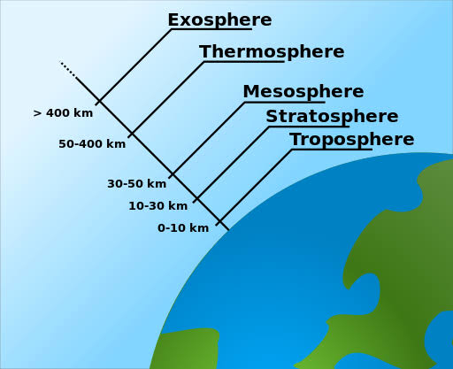
The atmosphere consists of almost concentric layers of air with varying density & temperature.
a) Troposphere:
• Lowest layer of the atmosphere.
• The height of troposphere is 16 km thick over the equator & 10 km thick at the poles.
• All weather phenomena are confined to troposphere (e.g. fog, cloud, frost, rainfall, storms, etc.)
• Temperature decreases with height in this layer roughly at the rate of 6.5° per 1000 metres, which is called normal lapse rate.
• Upper limit of the troposphere is calledtropopause which is about 1.5 km.
• b) Stratosphere:
• The stratosphere is more or less devoid of major weather phenomenon but there is circulation of feeble winds & cirrus cloud in the lower stratosphere.
• Jet aircrafts fly through the lower stratosphere because it provides perfect flying conditions.
• Ozone layer lies within the stratosphere mostly at the altitude of 15 to 35 km above earth's surface.
• Ozone layer acts as a protective cover as it absorbs ultra-voilet rays of solar radiation.
• Depletion of ozone may result in rise of temperature of ground surface & lower atmosphere.
• Temperature rises from -60°C at the base of the stratosphere to its upper boundary as it absorbs ultra-voilet rays.
• Upper limit of the Stratosphere is calledstratopause.
c) Mesosphere
• Mesosphere extends to the height of 50-90 km.
• Temperature decreases with height. It reaches a minimum of -80°C at an altitude of 80-90 km
• The upper limit is called mesopause.
d) Thermosphere
• It lies at 80 km to 640 km above the earth's surface.
• It is also known as ionosphere.
• Temperature increases rapidly with increasing height.
• It is an electrically charged layer. This layer is produced due to interaction of solar radiation & the chemicals present, thus disappears with the sunset.
• There are a number of layers in thermosphere e.g. D-layer, E-layer, F-layer & G-layer.
• Radio waves transmitted from earth are reflected back to the earth by these layers.
e) Exosphere
• This is the uppermost layer of the atmosphere extending beyond the ionosphere.
• The density is very low & temperature becomes 5568°C.
• This layer merges with the outer space.
About Ionosphere
At heights of 80 km (50 miles), the gas is so thin that free electrons can exist for short periods of time before they are captured by a nearby positive ion. This portion of the atmosphere is ionized & contains plasma which is referred to as the ionosphere. The Ultraviolet (UV), X-Ray & shorter wavelengths of solar radiation ionizes the atmosphere. The ionosphere is broken down into the D, E & F regions.

PRESSURE & WIND BELTS
Air pressure is thus defined as total weight of a mass of column of air above per unit area at sea level. The amount of pressure exerted by air at a particular point is determined by temperature & density which is measured as a force per unit area.
• Aneroid Barometer-It is the most commontype barometer used in homes.
Earth Mountains
Types of Mountains
· Fold Mountains: They are formed when the rocks of the crust of the earth folded under stress, mainly by forces of compression (as a result of series of earthquakes). E.g. – All big Mountain Systems: Himalayas, Alps, Andes, Rockies, Atlas, etc.
· Block Mountains: When large areas are broken and displaced vertically, Block Mountains are formed. In this case, the uplifted blocks are called horsts. On the other hand, the lowered blocks are called graben.
· Relict Mountains: Sometimes, the mountains are carved out as a result of erosion of plateaus & high planes by various agents of erosion. E.g., Highlands of Scotland, Sierras of Spain, Catskill mountains of New York & Nilgiri, Parasnath, Girnar, Rajmahal of India.
· Volcanic Mountain: A mountain formed due to volcanic activity is called Volcanic Mountain. Examples of Volcanic Mountains are; Mt. Kilimanjaro and Mt. Fujiyama.


No comments:
Post a Comment